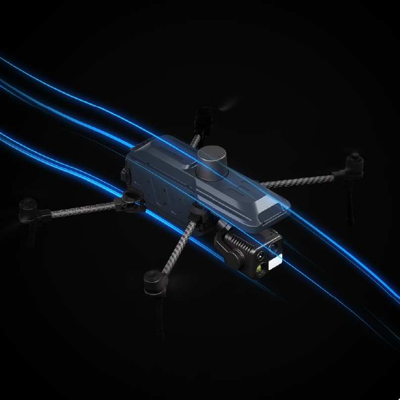
Taking Aerial Awareness Further.
01
Foldable Design
The foldable airframe combines lightweight construction with structural strength, making transportation and deployment easier while ensuring every mission starts efficiently.
02
Reliable Performance
With Level 6 wind resistance and precision hovering capabilities, the platform delivers stable flight performance and extended endurance, even in challenging environments.
03
Multi-Sensor
Equipped with the HEQ K40T AI Gimbal Camera, the system supports HD video transmission, intelligent target recognition, and multi-scenario aerial sensing to improve inspection efficiency and mission effectiveness.
Foldable Design. Max Efficiency.
The foldable airframe balances lightweight portability with structural durability, significantly improving transportation and deployment efficiency without compromising reliability. Whether for inspections, search and rescue operations, or outdoor field missions, the platform is ready to perform wherever the mission takes you.
Wind Resistant. Long Endurance.
Built to withstand Level 6 winds for reliable and stable flight performance.
45–50 minutes of flight time provides extended operational endurance for longer missions.
Hovering Accuracy: ±0.1m
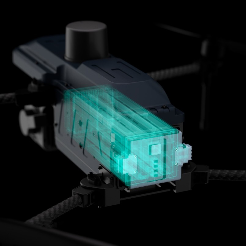
Quad-Sensor Vision. Day and Night.
The platform comes standard with the HEQ K40T Quad-Sensor Gimbal Camera, integrating dual 48MP cameras, thermal imaging, and laser ranging for night surveillance, long-range observation, and enhanced situational awareness.
Other HEQ payloads are also available.
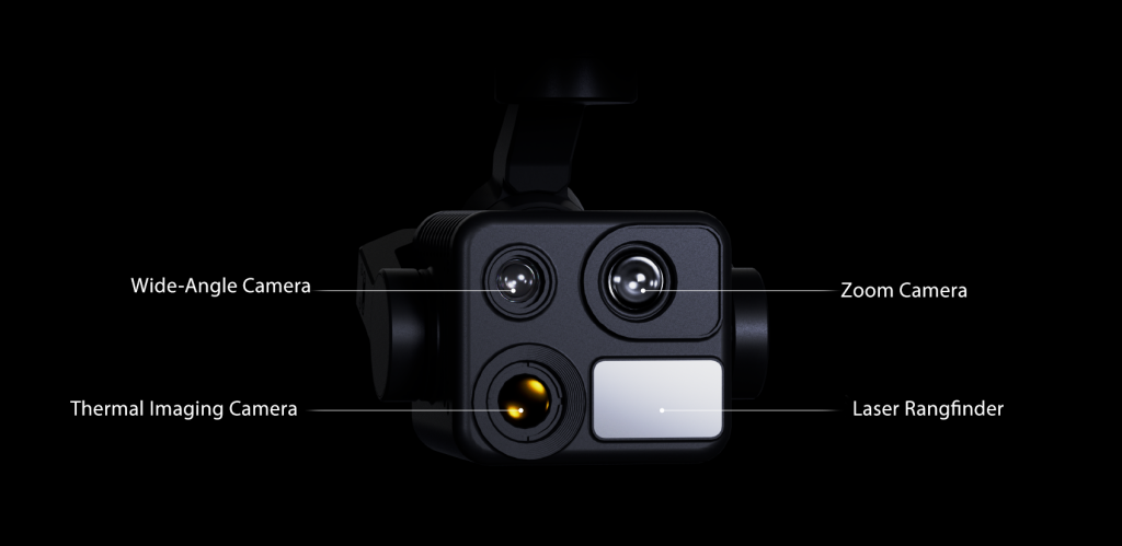
Wide or Telephoto. See It All.
Wide-angle and telephoto cameras work together to provide broad area coverage and detailed long-range observation. Seamlessly switch between perspectives for faster and more accurate target identification.
Thermal Fusion.
Visible-light and thermal imaging are fused through super-resolution technology, overcoming the limitations of single-sensor systems. Capture clearer, more intuitive mission-critical information day or night.
AI Tracking. Locked On Target.
Powered by a 1200m high-precision laser rangefinder and advanced AI recognition algorithms, the system enables long-range target identification, continuous tracking, and stable imaging.
Long-Range Control. Clear at a Glance.
Package comes with Scepter-15, the Newest HEQ Remote Controller, which provides a 10–12.5km control range and smooth, real-time video transmission, keeping critical information at your fingertips throughout the mission.
Specifications
| Dimensions |
Folded: 291 × 147 × 175mm Unfolded (with propellers): 630 × 558 × 175mm |
| Frame Material | Carbon Fiber + Plastic |
| Wheelbase | 480mm |
| Takeoff Weight | 1450 ±5g |
| Max Payload | 300g |
| Recommended Payload | 300g |
| Flight Time | 45–50min |
| Recommended Cruise Speed | 8–15m/s |
| Max Horizontal Speed | 20m/s |
| Max Wind-resist Speed | 12m/s |
| Max Takeoff Altitude | 4000m |
| Max Ascent Speed | 6m/s |
| Max Descent Speed | 4m/s |
| Max Transmission Range | 10–12.5km (FCC, Unobstructed) |
| Mission Altitude | Recommended Below 1000m |
| Wind Resistance | Level 6 |
| Working Environment Temperature | -10 °C ~ 40 °C |
| GNSS Positioning Systems | GPS + Galileo + BeiDou + GLONASS |
| Hover Time | 35–40min |
| Hovering Accuracy |
Vertical: ±0.1m (Vision Positioning), ±0.5m (GNSS Positioning) Horizontal: ±0.3m (Vision Positioning), ±0.5m (GNSS Positioning) |
| Unfolded Dimensions | 661mm × 583mm × 175mm |
| Design | Foldable |
| Positioning System | GNSS + Optical Flow + ToF |
| Communication Band | 2.4GHz / 5.8GHz Standard (Custom Frequencies Available) |
| Target Localization | Supported |
| Battery Capacity | 4S 12500mAh |
| Standard Package | Drone, K40T AI Gimbal Camera, Scepter-15 Controller, 2 Sets of Propellers, Carrying Case |
| Axis Type | 3-Axis Mechanical Stabilization |
| Control Range |
Pitch: -135° to +45° Roll: -45° to +45° Yaw: -135° to +135° |
| Max Control Speed | 180°/s |
| Angular Vibration Range | ±0.005° |
| Dimensions | 114 × 84 × 95mm |
| Interfaces | Ethernet / Serial Port / SBUS |
| Thermal Camera | |
| Detector Type | VOx Uncooled Infrared Focal Plane Detector |
| Thermal Resolution | 640 × 512 |
| Focal Length | 13mm |
| Pixel Pitch | 12μm |
| Frame Rate | 50Hz / 25Hz |
| Spectral Band | 8~14μm |
| Wide-Angle Camera | |
| Sensor Size | 1/2" |
| Effective Pixels | 48MP |
| FOV | H: 71° V: 56° D: 84°±1° |
| Focal Length | 4.49mm |
| Aperture | F2.8 |
| Telephoto Camera | |
| Sensor Size | 1/2" |
| Effective Pixels | 48MP |
| Variable Aperture | F3.7 ~ F4.6 |
| Effective Focal Length | 15.2~50mm |
| Laser Rangefinder | |
| Measurement Range | 5~1200m |
| Measurement Accuracy | ±1m |
| Image Transmission | |
| Antenna | Dual Antenna |
| Operating Frequency | 2.4GHz + 5.8GHz |
| Maximum Effective Signal Range | 15km |
| EIRP | 15dBm ~ 27dBm |
| WiFi | |
| WiFi Protocol | IEEE 802.11a/b/g/n/ac |
| Operating Frequency | 2.4G / 5G |
| WiFi EIRP | 17dBm (Max) |
| Bluetooth | |
| Bluetooth Protocol | Bluetooth 5.0 |
| Operating Frequency | 2.4G |
| Bluetooth EIRP | 8dBm (Max) |
| Display | |
| Resolution | 1920×1080 |
| Frame Rate | 60FPS |
| Size | 5.5 inches |
| Maximum Brightness | 1000 nits |
| Touch | 5-point Multi-touch |
| Battery | |
| Battery Capacity | 5000mAh |
| Charging Time | 1.5 hours (Power Off) |
| Charging Method | PD 30W Fast Charging |
| Operating Time | 4.5 hours |
| General Parameters | |
| Operating System | Android 11 |
| Weight | 700g |
| HDMI Output | 1080P |
| Hardware Interfaces | Charging: USB Type-C External Storage: TF Card |
| Protection Level | IP53 |
| Operating Temperature | -10°C ~ 45°C |
| Memory | 4GB RAM + 32GB Storage |
| Dimensions | 175×137×47.4mm / 175×137×64mm |
| Receiver Parameters | |
| SBUS | 3-Pin |
| Data Transmission | UART 4-Pin |
| Network Interface | GH1.25-4P |
| USB Interface | GH1.25-4P / Type-C |
| Remote Control Signal | 16 Channels SBUS |
| Receiver Weight | 50g (Without Antenna) |
| Antenna Gain | 3dBi |
| Working Voltage | 12V-27V |
| Working Environment Temperature | -10°C ~ 45°C |
| Receiver Size | 57 × 47 × 18.1mm |
I'd like to buy one, but I'm worried it might be difficult to use.
You can visit the HEQ YouTube channel to watch our tutorial series before making a purchase decision.
We also publish firmware updates, setup guides, and feature demonstrations on the channel to help users get the most out of their gimbals.
Ready For Takeoff?
Explore other HEQ UAV platforms—whether your focus is aerial imaging, industrial operations, or professional applications, there’s a platform built for your mission. We also update industry news and insights. Contact our team today for the latest pricing, product information, and customized solutions.